Berthoud Pass Road Conditions | Live Traffic Cams
Is Berthoud Pass Open or Closed Right Now?
Berthoud Pass (US-40) Status: OPEN
Berthoud Pass Quick Facts:
| Summit | 11,315 ft (Continental Divide) |
| Length | ~15 miles (Empire to Winter Park) |
| Grade | 6.3% |
| Avg Snowfall | 391 inches per year |
| Avalanche Paths | 55+ mapped on corridor |
| Winter Closures | Frequent (avalanche control) |
Berthoud Pass (US-40) is one of Colorado’s most challenging mountain corridors, crossing the Continental Divide at 11,315 feet between Empire and Winter Park. With over 55 mapped avalanche paths and an average annual snowfall of 391 inches, this pass demands respect from winter drivers. The route features steep 6.3% grades and numerous switchbacks, particularly on the south (Empire) side. CDOT employs advanced avalanche mitigation systems, including Gazex and O’bellx technology, to manage snow hazards. This page provides real-time data from CDOT to support safe travel decisions.
Berthoud Pass Map
Berthoud Pass Live Traffic Cameras
Berthoud Falls (Looking East)

Summit Area (Looking West)
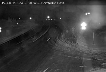
Camera images refresh automatically. Images may be delayed during high traffic periods.
Berthoud Pass Travel Advisories & Alerts
Current Travel Advisories for Berthoud Pass (US-40)
- Traction Law in effect (Sept 1 - May 31): Passenger vehicles require AWD/4WD with adequate tread OR chains.
- MAINTENANCE: US-40W - Maintenance Operation S: Between Henderson Mine Road And Mary Jane Ski Area (Near Winter Park) From Mile Point 238 To Mile Point 236. Road Maintenance Operation S. There Is Alternating Traffic. Slower Speeds Are Advised. Comment: The WB Lane Is Closed. Alternating Traffic Pattern In The EB Lanes.
Traction Law Reminder: Colorado’s Passenger Vehicle Traction Law and Commercial Vehicle Chain Law are in effect statewide September 1 through May 31. Passenger vehicles require snow tires (3/16″ tread minimum), all-season tires meeting specs, or 4WD/AWD. Commercial vehicles must carry and install chains when activated.
Current Road Surface & Weather Conditions
Real-Time Weather Data for Berthoud Pass (US-40)
Sensor note: the primary weather station for this report sits at Fraser Flats, north of and below the pass. Expect temperatures at the 11,315-foot summit to run roughly 10 degrees colder than the station reading.
Weather Forecast & Travel Impact
Weather Forecast for Berthoud Pass (US-40)
National Weather Service forecasts mostly cloudy for the next 5 hours (through 8:25 PM MST).
What to Expect for Berthoud Pass (US-40):
Current Travel Conditions for Berthoud Pass (US-40)
Traffic Conditions for Berthoud Pass (US-40)
Avalanche Mitigation & Safety
Berthoud Pass has one of the highest concentrations of avalanche paths affecting any Colorado highway. CDOT employs multiple mitigation strategies:
| System | Description | Location |
|---|---|---|
| Gazex | Remote-controlled gas explosion system | Multiple slide paths |
| O’bellx | Propane-fueled concussion system | Stanley avalanche path (#5) |
| Artillery | Traditional explosive control | Used when conditions require |
| Hand Charges | Manual placement by trained crews | Targeted areas as needed |
55+ Avalanche Paths: Multiple slide paths intersect US-40 on Berthoud Pass, with some crossing the highway at multiple points. CDOT’s avalanche mitigation crew actively manages these hazards throughout winter, sometimes triggering controlled slides multiple times per week during active storm cycles.
Safety Closure Protocol: When avalanche danger is high or mitigation work is required, CDOT implements safety closures with little advance notice. Closures typically last 15 minutes to several hours, depending on conditions and the scope of work.
Why Does Berthoud Pass Close?
Berthoud Pass is one of the most frequently closed mountain passes in Colorado due to its extreme conditions:
| Closure Reason | Threshold | Typical Duration |
|---|---|---|
| Avalanche Control | High danger requiring mitigation | 15 min – 3 hours |
| Natural Avalanche | Slide blocks roadway | 1-6+ hours |
| Heavy Snow | Accumulation exceeds plowing capacity | 2-8 hours |
| Visibility | Whiteout conditions | 30 min – 3 hours |
| Vehicle Accidents | Spinouts, multi-car incidents | 30 min – 3 hours |
| Extreme Winds | Sustained 50+ mph | 1-4 hours |
Record Snowfall: With average annual snowfall of 391 inches (over 32 feet), Berthoud Pass receives some of the heaviest precipitation in Colorado’s highway system. Storm cycles can drop 2-3 feet of snow in 24 hours, overwhelming plowing operations and triggering widespread avalanche activity.
Alternative Routes When Berthoud Pass Is Closed
To Winter Park/Fraser Valley: When Berthoud Pass closes, the primary alternate is I-70 west through the Eisenhower Tunnel to Silverthorne, then US-40 north to Winter Park. This adds approximately 45 miles and 45-60 minutes.
To Granby/Grand Lake: From Denver, take I-70 west to Exit 205 (US-40), north through Kremmling to Granby. Alternatively, from Boulder, take CO-72 to CO-119 through Nederland to US-40 (when road conditions permit).
Winter Alert: During major storms, Berthoud Pass often closes simultaneously with I-70 and other mountain corridors. Always check COtrip.org for all routes before departing. Consider delaying travel during significant storm events.
When the pass closes for avalanche work, Blue Sky Limo’s Denver to Winter Park car service makes the reroute call for you; the full detour picture is in our guide to alternative routes to Winter Park.
Safely Driving Over Berthoud Pass
Winter Driving Tips:
- Low Gear: Use low gear on the 6.3% grade to prevent brake fade.
- Switchback Caution: South side has numerous tight turns—slow down.
- Avalanche Zones: Do not stop in marked avalanche areas.
- Stay Alert: Watch for snowplows and CDOT avalanche crews.
Vehicle Requirements
- Snow tires with mountain/snowflake symbol, OR
- All-season tires with 3/16″ tread (M/S rated)
- 4WD/AWD highly recommended
- Chains required for 2WD when Code 15 active
Frequently Asked Questions
Is Berthoud Pass open in winter?
Yes, Berthoud Pass is maintained year-round. However, it is subject to frequent temporary closures for avalanche control, snow removal, and adverse conditions. During major storms, expect delays or extended closures.
How many avalanche paths are on Berthoud Pass?
Over 55 avalanche paths have been mapped on Berthoud Pass, making it one of the most avalanche-prone highway corridors in Colorado. Some paths cross the highway at multiple points.
What is the alternate route to Winter Park when Berthoud Pass is closed?
Take I-70 west through the Eisenhower Tunnel to Silverthorne (Exit 205), then US-40 north to Winter Park. This adds approximately 45 miles and 45-60 minutes to your trip.
Why are there so many closures on Berthoud Pass?
Berthoud Pass receives an average of 391 inches of snow annually with 55+ avalanche paths. The combination of extreme snowfall, steep terrain, and multiple avalanche zones requires frequent safety closures for mitigation work.
Is there cell phone coverage on Berthoud Pass?
Cell coverage is spotty on Berthoud Pass. Coverage is generally better near the summit and Winter Park side, but may be limited or absent in the canyon sections on the Empire side.
You Don’t Have to Drive Berthoud Pass
Blue Sky Limo runs private car service from Denver to Winter Park over Berthoud Pass all winter in AWD SUVs that meet Colorado’s traction law. Your driver tracks avalanche closures and chain laws so you don’t have to.
Status Reports for Other Colorado Mountain Routes & Passes
Blue Sky Limo provides real-time road condition reports using live CDOT COtrip data, refreshed every five minutes. Select a route below for current conditions, traffic cameras, and travel advisories before your mountain drive.
Additional CDOT Road Resources:
Visit COtrip.org for real-time road conditions, live webcams, and closure alerts for all Colorado highways. Download the CDOT mobile app (iOS | Android) to view traffic cameras, track snowplow locations, and receive push alerts for closures. Follow @ColoradoDOT on X for immediate updates on chain law activations and major incidents. For recorded Colorado road condition updates, call:
- 511 (within Colorado)
- 303-639-1111 (Denver metro)
- 877-315-7623 (toll-free statewide)
Mountain weather directly impacts road conditions and closure timing across Colorado. Check the National Weather Service forecast for storm warnings and precipitation timing before traveling. During winter months, the Colorado Avalanche Information Center posts forecasts that often signal upcoming closures for avalanche control on mountain passes and corridors.
Data Source: Colorado Department of Transportation (CDOT) COtrip API | Refreshed every 5 minutes